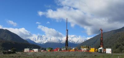
A collaboration by scientists who drilled nearly 900 metres into the South Island’s Alpine Fault has revealed surprisingly high temperatures and the potential for large geothermal resources in the area.
The site was drilled by a team of more than 100 scientists from 12 countries, who were working to understand how earthquakes occur on geological faults.
The team identified the Whataroa site as the best place in the world to understand what a fault looks, feels, and sounds like just before an earthquake occurs. The Alpine Fault is known to rupture in magnitude 8 earthquakes approximately every 300 years, plus or minus 90 years.
The results of the project, published today in prestigious international journal Nature, discuss the site’s geothermal gradient—a measure of how fast the temperature increases going deeper beneath the Earth's surface.
The project team discovered water at 630 metres depth that was hot enough to boil. Similar geothermal temperatures are normally found at depths greater than three kilometres.
Lead scientist Victoria University’s Professor Rupert Sutherland says the geothermal conditions discovered are extreme by global standards and comparable to those in major volcanic centres like Taupo—but there are no volcanoes in Westland.
“The geothermal environment is created by a combination of tectonic movement and groundwater flow. Slippage during earthquakes has uplifted hot rocks from about 30 kilometres deep, and the rocks are coming up so fast that they don't get a chance to cool properly.
“Earthquakes fracture the rocks so extensively that water is able to infiltrate deep beneath the mountains and heat becomes concentrated in upwelling geothermal fluids beneath valleys. River gravels that are flushed by abundant West Coast rain and snow dilute this geothermal activity before it reaches the surface.
"Nobody on our team, or any of the scientists who reviewed our plans, predicted that it would be so hot down there. This geothermal activity may sound alarming but it is a wonderful scientific finding that could be commercially very significant for New Zealand."
The discovery could transform the economy and resilience of Westland, and provide a significant and sustainable clean energy resource that could be developed using local people and equipment, says Warren Gilbertson, Chief Operating Officer of Development West Coast.
"The location of geothermal activity and its possible benefit and association to the dairy and tourism sectors provide real opportunities from an economic perspective.”
It is still too early to say just how big and how hot the geothermal resource might be, says Professor Sutherland, and additional exploration and drilling will be needed to assess the economic potential.
Novel technologies were used to gather the data, including precise temperature and seismic measurements that were made using lasers and a fibre-optic cable installed in the borehole. Ongoing work, supported by the Marsden Fund managed by the Royal Society of New Zealand and led by Professor Neil Broderick from the University of Auckland, aims to develop these technologies and use the existing borehole to monitor subtle changes and search for new earthquake-related phenomena over coming years.
Overall, the Deep Fault Drilling Project fell short of achieving all of its technical goals as the fractured and strongly-layered rocks and extremely hot temperatures provided engineering challenges.
However, many scientific measurements were made and the borehole continues to provide interesting data, says Victoria’s Professor John Townend, a co-leader of the project.
"In scientific research, unexpected is just another word for really interesting. The findings reinforce the need for the international science community to better understand conditions that prevail around earthquake-generating geological faults."
| A Victoria University of Wellington release || May 18, 2017 |||


